The Serre-Ponçon reservoir offers 10 public harbors open to all, subject to reservation with the harbor master's office. a total of 1,250 moorings are available across the lake, so you can be as close as possible to where you live or stay.
Port reservations open at noon on January 1.
By pre-booking your mooring on our website, you can select the desired port (subject to availability) from those listed below:
Book my anchorage in Serre-Ponçon
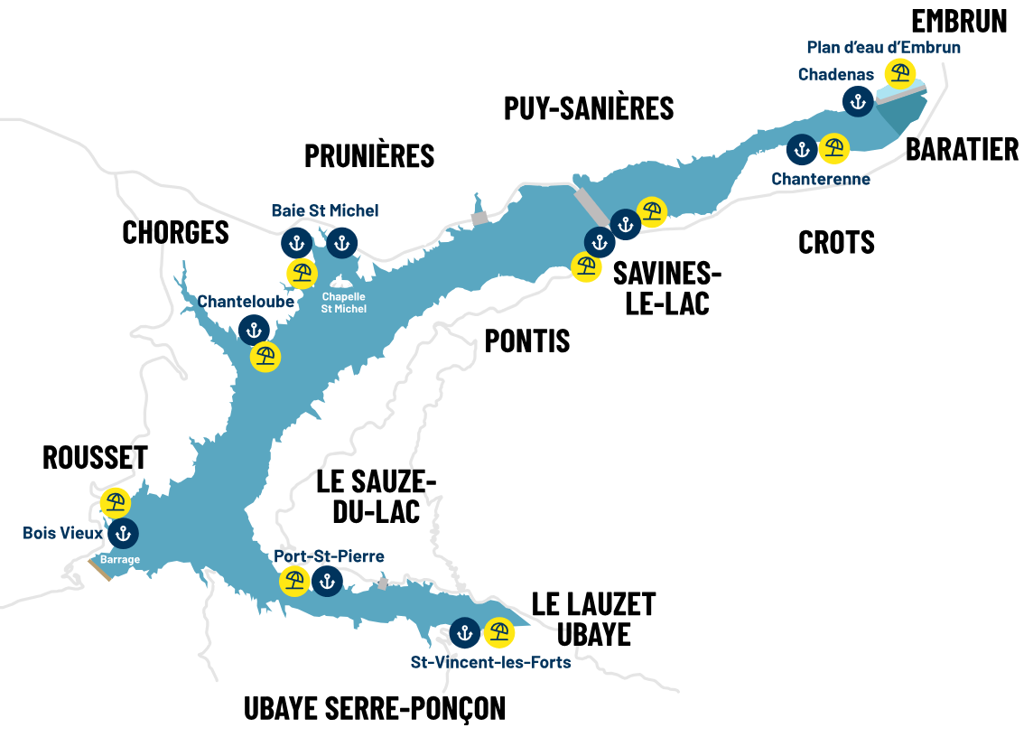
Chanteloube harbour Chorges
A port nestled between heritage and nature
Moor your boat in a bay famous for its ancient viaduct and its green setting, sail around a renowned heritage while immersing yourself in a natural setting - that's what the Chanteloube harbor has to offer.
If this port doesn't have a slipway, the one at Baie Saint Michel will enable you to launch your boat to reach this bay.
Port facilities :
pontoon with electrical terminals
moorings
ISO 18725 "Active biodiversity harbors" standard

Port de Bois vieux Rousset Serre-Ponçon
A port nestled in a green Mediterranean setting
Explore the pine forest, paddle near the dam (while staying within the 300-meter safety zone marked by buoys), and enjoy the incredible views between the Ubaye River and the upper reaches of Lake Serre-Ponçon. this is what the port of Bois Vieux has to offer .
Facilities:
- Anchorage spots only
- A boat launch ramp extending to elevation 763.10m NGF (usable depending on the boat’s draft, up to a 16m tidal range)
Clean Ports and Biodiversity-Active Ports Label

Port de la Baie Saint Michel Chorges
The largest port on Lac de Serre-Ponçon
Between the Chapelle de la Baie Saint Michel and the Pic du Morgon, this harbor offers an incredible panorama. This dynamic space will provide you with an appreciable sailing environment. The Baie Saint Michel harbor is one of the major ports in the Serre-Ponçon reservoir.
Facilities :
- Pontoon with access to electricity
- Fuel station
- Careening area
- Grey and black water stations
- A launching slipway built up to 764.20m NGF (ramp) and 761.10m NGF (foot of quay), for use down to -15.00m and -17.50m respectively, depending on the boat's draught
Baie Saint Michel Mooring Plan
Plan Pontoon A Baie Saint Michel
Plan Pontoon B Baie Saint Michel
Plan Pontoon C Baie Saint Michel
ISO "Clean Harbors" and "Active Biodiversity Harbors" certification
https://www.ports-propres.org/

Port of Prunières Plums
The port opposite the Chapelle Saint Michel
Offering panoramic views of the Pic du Morgon and the Chapelle Saint Michel, the Prunières harbor located on the CSLG (Club Sportif de Loisirs et de la Gendarmerie) will welcome you.
If you wish to benefit from access to the parking lot, showers and sanitary facilities, a membership fee will be required by the club (contact 04 92 50 68 20)
Facilities :
- Pontoon without electricity
- Fuel station and careening area located nearby in the Baie Saint Michel harbor.
A slipway adapted to a water level of - 5 m at Baie Saint Michel.
ISO "Clean Harbors" and "Active Biodiversity Harbors" certifications
https://www.ports-propres.org/ports-certifies/05-port-de-prunieres/

Port de la Capitainerie Savines-le-lac
The harbour of the captaincy of the lake of Serre-Ponçon
In the heart of the village of Savines-le-lac, you can moor your boat. At the foot of the Morgon, you can continue your discovery of this attractive tourist village on foot.
The Capitainerie harbour offers you the following facilities and services:
Facilities :
- pontoon with electricity
- berths on moorings
- fuel station
- slipway up to 765m NGF, for use depending on the boat's draught, down to a water level of -14 m
pRM elevator
Map of the Capitainerie harbor - Savines Le Lac
ISO "Clean Harbors" and "Active Harbors in Biodiversity" certification
https://www.ports-propres.org/ports-certifies/05-port-de-prunieres/

Port du Barnafret Savines-le-lac
The port nestled in a cove
Ideally nestled in a cove in the commune of Savines-le-lac, the Barnafret harbor offers a privileged location close to all the commune's shops. Bordered by a footpath, you'll enjoy privileged access to the Savin'plage beach.
Facilities :
- pontoon with electricity
- fuel station nearby (at the Savines-le-lac harbor)
launching dock adapted to a water level of -15 m nearby (at the Savines-le-lac Harbour Master's Office)
Clean Ports" and "Active Biodiversity Ports" certification
https://www.ports-propres.org/ports-certifies/05-port-de-prunieres/

Port des Eygoires Savines-le-lac
The port of the fishing hut
Located near Savines-le-Lac on the way to Ubaye, the Eygoires site offers around twenty moorings for yachtsmen. Near the slipway, built to 751 NGF, you'll also find the fishermen's hut, an "Info-pêche" point managed by the Hautes-Alpes fishing federation .
Facilities :
- moorings
slipway up to elevation 751 (-29 m).

Port Saint Pierre harbour Le Sauze-du-lac
The port on the foothills of the Morgon peak
From the port of Port Saint Pierre, a footpath leads to the hilltop village of Sauze-du-Lac, where you'll find a belvedere offering a majestic view of the Serre-Ponçon dam. Backing onto the beach, you'll appreciate the Mediterranean setting of this site.
Facilities :
- pontoon with electricity
- fuel station
- nearby slipway suitable for -9 m water level
Map of Port Saint Pierre - Le Sauze du Lac harbor
- ISO "Clean Harbors" and "Active Biodiversity Harbors" certification
https://www.ports-propres.org/ports-certifies/05-port-de-prunieres/

Port of Saint Vincent-les-forts Ubaye Serre-Ponçon
The Ubayenne valley port
Located on the Ubaye branch of the Serre-Ponçon Reservoir, this marina offers you exclusive access to the beach at Saint-Vincent-les-Forts. Dive into the heart of the Alpes-de-Haute-Provence department, where you can enjoy boating downstream along the Ubaye River.
Facilities:
- pontoon with electricity
- mooring spots
- nearby fuel station (located at the Port of Port Saint Pierre)
launching ramp equipped up to elevation 763.36 m NGF, usable depending on the boat’s draft, down to a water level drop of -16 m
Map of the Port of Saint Vincent-les-Forts
Map of Saint Vincent-les-Forts moorings
ISO certification for "Clean Ports" and "Biodiversity-Friendly Ports"
https://www.ports-propres.org/ports-certifies/05-port-de-prunieres/

Port of Chadenas Puy Sanières and Embrun
Wearing a tailcoat
Located between Embrun and Puy Sanières, the Chadenas harbor offers an atypical panorama between the Embrun lake and the Serre-Ponçon reservoir.
You can access the Chadenas slipway via the Club Nautique Alpin campsite.
Facilities :
- pontoon without electricity
- slipway adapted to a water level of - 5 m
- ISO "Clean Ports" and "Active Biodiversity Ports" certification
https://www.ports-propres.org/ports-certifies/05-port-de-prunieres/

Chanterenne Harbour Crots
The port facing the majestic Mont Guillaume
Facing one of Serre-Ponçon's iconic peaks, the Chanterenne harbor offers mooring spaces at the foot of Mont Guillaume. The port provides direct access to the Chanterenne beach.
Facilities :
moorings
ISO "Clean Harbors" and "Active Harbors in Biodiversity" certification
https://www.ports-propres.org/ports-certifies/05-port-de-prunieres/

Lake port regulations
Click on the link below to read the harbor regulations:
For further information,please contact the harbor master's office on 04.88.26.02.06.
